Discover Arizona Mining Country
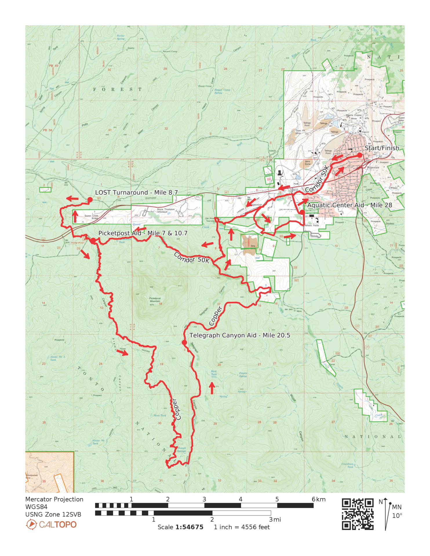
The Copper Corridor Trail Runs depart from the old mining town of Superior, Arizona which serves as the start & finish line. Runners will head West of town towards Arnette Canyon where they will enter a riparian wonderland of flowing creeks, towering rock formations and dense sycamore trees.
32 Km entrants will traverse the length of Arnett to Picketpost Trailhead and get a taste of the Arizona Trail for two miles before returning back to town. 50 Km runners will continue South bound on the Arizona Trail for a circumnavigation of the mighty Picketpost Mountain before making their way back to Superior to finish on Main Street!
Exploring the Copper Corridor
Race Information
Welcome to the eighth annual Copper Corridor Trail Runs in 2027! This soon to be well known area is currently a hidden gem in Arizona. Be one of the first to discover this amazing area of Arizona which is not too far from Phoenix geographically, but a world away in so many ways. Discover the beauty and history of this land rich in resources and views.
With a race start & finish right in downtown Superior this is an Aravaipa race you won’t soon forget. You’ll soon leave the quiet town behind as you venture into rugged and awesome desert country complete with Saguaro cactus forests, flowing creeks and rock formations reminiscent of the Superstition Wilderness or Bryce Canyon.
For those looking for a full day’s worth of adventure, sign up for the 50K which features many miles of the Arizona Trail and a loop around the iconic Picketpost Mountain!
Be sure to stick around for and afternoon of exploring Main Street, taking in the sights and sharing some well earned post race refreshments around town. Several bars will have live music Saturday evening.
Start Times
Saturday, February 27, 2027
7:00 AM – 50 Km Start
7:30 AM – 32 Km Start
8:00 AM – 17 Km Start
8:30 AM – 12 Km Start (Start & Finish at Superior Public Pool)
Start/Finish Line Location
50K – 32K – 17K:
Downtown Superior, AZ
165 Main Street
Superior, AZ 85173
12K:
Superior Public Pool
234 S. Golf Course Road
Superior, AZ 85173
Bib Pickup
Friday, February 26, 2027
Packet Pickup 6:00-7:30PM
Main Street Superior
101 W. Main Street
Superior, AZ 85173
Saturday, February 27, 2027
Race Day Pickup 6:15-8:30AM
Location:
Downtown Superior, AZ
50K – 32K – 17K (Downtown Superior)
12K (7:15a-8:30am) (Superior Public Pool)
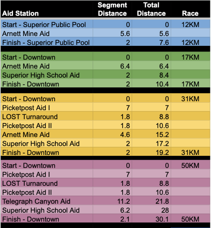
Aid Stations
Aid stations every 2 to 10 miles including water, electrolyte drink, sweet snacks, salty snacks, and fruit. Please plan to run with at least one to two bottles of water. Please note, the aid station at Telegraph Canyon is remote and minimal aid including water and a few salty/sweet snacks will be trucked in by volunteers. Please prepare accordingly.
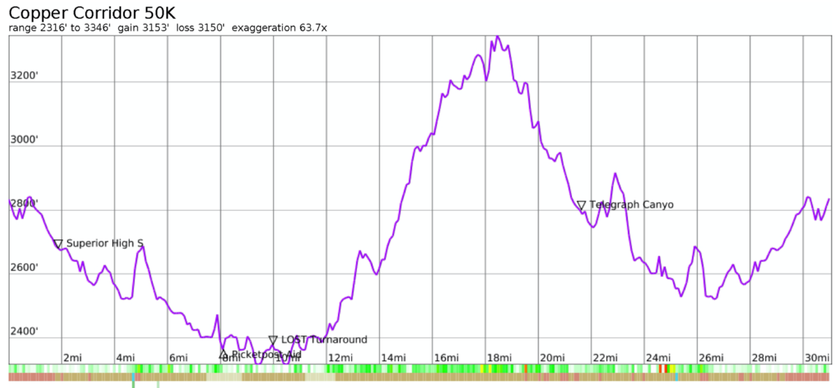
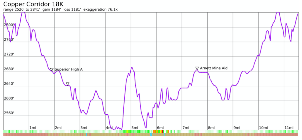
50K Map & Profile
50K Interactive Map on CalTopo
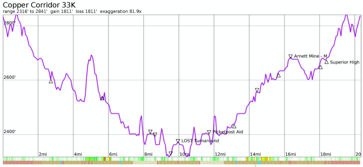
32K Map & Profile
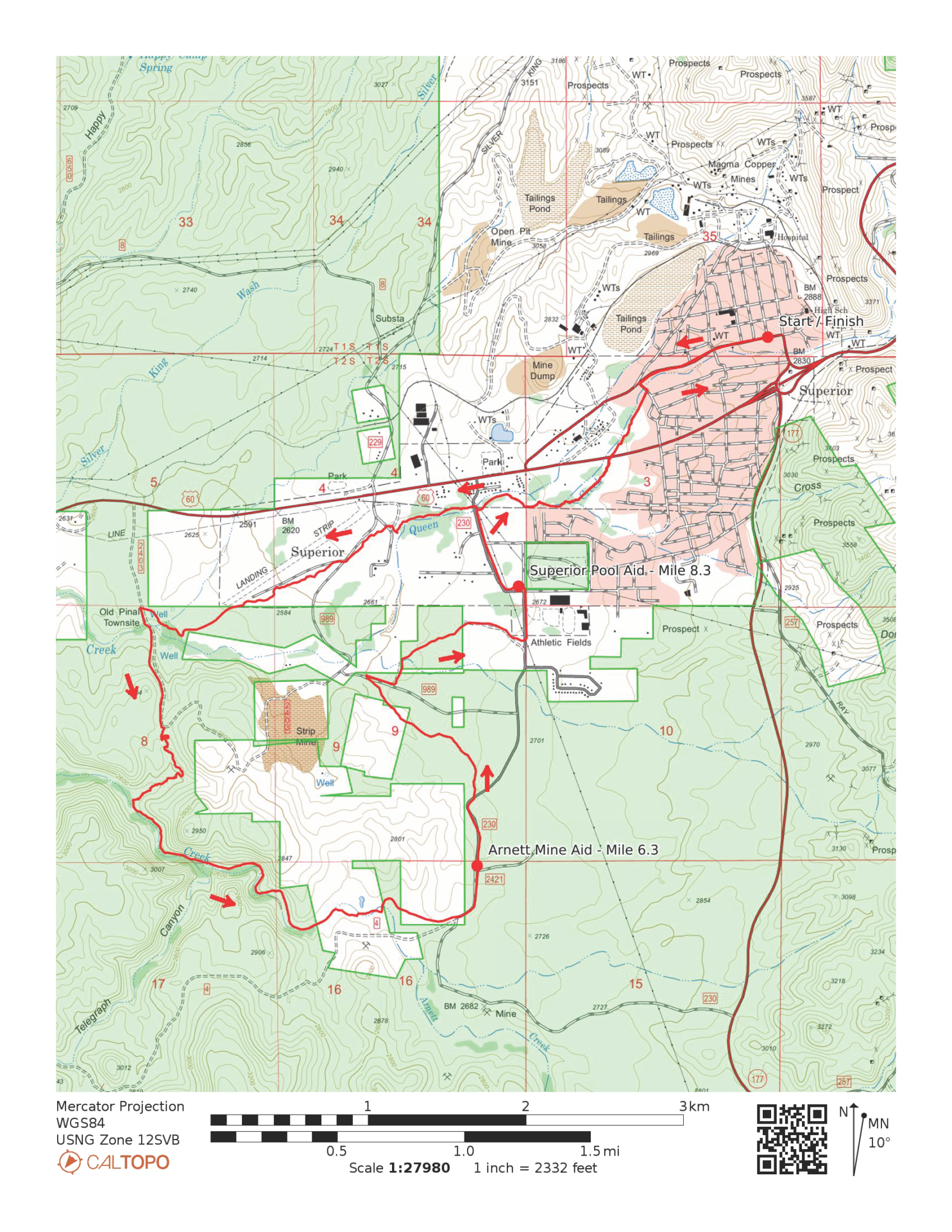
17K Map & Profile
17K Interactive Map on CalTopo
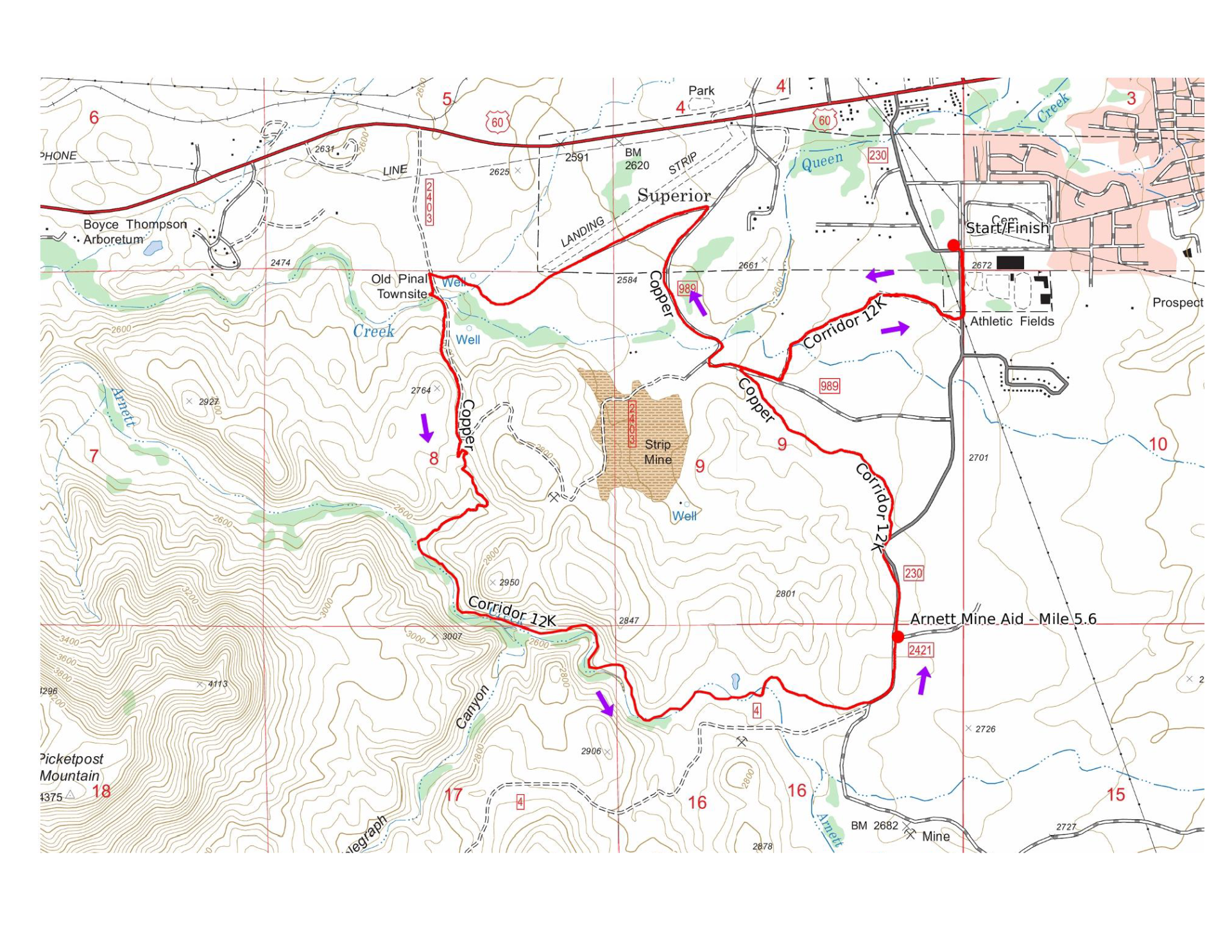
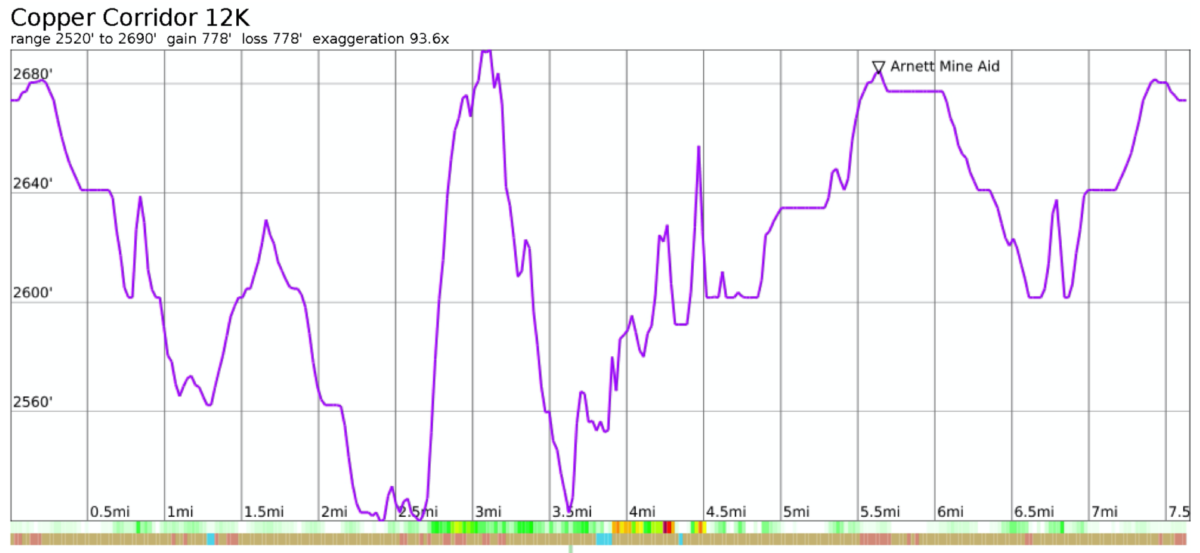
12K Map & Profile
12K Interactive Map on CalTopo
Event's current local time: 8:52 AM MT